179
179
Dec 7, 2012
12/12
by
KRON
tv
eye 179
favorite 0
quote 1
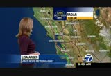
santa rosa is thing fall. currently 40 degrees there by today will be 63--santa rosa is sing foeeing fog. we will be right welcome back the time is 4:30 a.m. as we take a live look outside back at san francisco we can see the lights in that shot. no fog. but we do see dense fog in areas of the north bay. we are following a developing story out of japan where a strong earthquake jolted the norse etnorth eastern part of te country. a 7.3 magnitude or tearthquake struck in the pacific ocean around 518 local time. that is around midnight here in san francisco. the usgs said the earthquake struck about 200 mi. off the coast of japan. if the epicenter was about 6 mi. beneath the seabed. buildings in tokyo's way for several minutes. japanese meteorologies have lifted a tsunami warning for the country's northeastern coast. according to the tsunami informations center a destructive pacific wide tsunami is not expected. and there is no threat to why at this time. the quake off the coast of northeastern japan is the same
santa rosa is thing fall. currently 40 degrees there by today will be 63--santa rosa is sing foeeing fog. we will be right welcome back the time is 4:30 a.m. as we take a live look outside back at san francisco we can see the lights in that shot. no fog. but we do see dense fog in areas of the north bay. we are following a developing story out of japan where a strong earthquake jolted the norse etnorth eastern part of te country. a 7.3 magnitude or tearthquake struck in the pacific ocean around...
243
243
Dec 4, 2012
12/12
by
KRON
tv
eye 243
favorite 0
quote 1
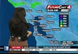
santa rosa and the green vinyl park is wet. that status or no, park >> here is a wider view on satellite and radar. high- pressure is keeping the track north this is kind of a slow mover. it might take a couple of hours to reach more parts of the north bay and then probably overnight will see more wet weather develop for the rest of the bay area. here is futurecast 4:03 p.m. you concede light rain for ssan raphael, a vallejo and napa. >> overnight for a in check out the yellow on your screen that does indicate a moderate to heavy rain again this is in the north bay where we expect maybe an inch of rain. about a quarter of an inch every hour else. you can see futurecast 4 predicts 8:00 a.m. to pick up your morning commute scattered showers around the bay area. it looks like in terms of temperatures temperatures are a bit more than 24 hours ago. 524 vallejo. napa 54 at oakland. into the afternoon upper 50s with the north bay low sixties for everyone else. 62 for concord. 63 in pleasanton they steady at 59 degrees. your kron 4 7 d
santa rosa and the green vinyl park is wet. that status or no, park >> here is a wider view on satellite and radar. high- pressure is keeping the track north this is kind of a slow mover. it might take a couple of hours to reach more parts of the north bay and then probably overnight will see more wet weather develop for the rest of the bay area. here is futurecast 4:03 p.m. you concede light rain for ssan raphael, a vallejo and napa. >> overnight for a in check out the yellow on...
143
143
Dec 4, 2012
12/12
by
KRON
tv
eye 143
favorite 0
quote 0
only getting to 59 for santa rosa and napa. 60 expected in the city. satellite and radar showed the rain sagging southward. the cold front is relatively weak in nature. compared to the last three systems we saw we will see a lot of cloud cover. most moisture heads towards the north. 9:00 a.m. picking up light rain and that will be the case throughout most of today. it looks like a lot of cloud cover will stick around waking up 9:00 a.m. tomorrow morning. maybe heavier rain in the north bay and light showers around the city. that will be the case as we head into the rest of tomorrow afternoon just light showers spreading to the bay area and then they will start to taper off. your kron 4 7 day around the bay forecast shows wet weather on tap for part of today and into tomorrow it looks like it will be tried by thursday overall mild conditions as we transition into the weekend. temperatures will be in the '60s. back to you. >> thank you so much erica i think we have a quick check of the traffic. let us go to george. good morning. >> thank you anny it as w
only getting to 59 for santa rosa and napa. 60 expected in the city. satellite and radar showed the rain sagging southward. the cold front is relatively weak in nature. compared to the last three systems we saw we will see a lot of cloud cover. most moisture heads towards the north. 9:00 a.m. picking up light rain and that will be the case throughout most of today. it looks like a lot of cloud cover will stick around waking up 9:00 a.m. tomorrow morning. maybe heavier rain in the north bay and...
125
125
Dec 3, 2012
12/12
by
KRON
tv
eye 125
favorite 0
quote 0
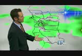
or portions of santa rosa. clear conditions everywhere else again we will see any increase in clouds into the afternoon. satellite and radar shows just that clouds making their way into the bay area. this is the head of a storm system that is expected to approach. futurecast 4 set up for 9:00 a.m. tomorrow light rain around santa rosa. i do not think we will see too much moisture associated with this system. most of the bay area will see maybe a quarter of an inch. that is nothing compared to what we experienced over the weekend. futurecast 4 by lunchtime spotty showers in vallejo and napa. relatively light in nature. 70 in tomorrow we could pick up some heavier rain that will continue to grow in intensity for the overnight hours and check out 9:00 a.m. wednesday morning heavier rain expected for parts of the bay area we will see clear conditions as we head into the afternoon. this is not a significant rainmaker. dryer by thursday it was a mix of sun and clouds. over all pretty mild conditions as we transition
or portions of santa rosa. clear conditions everywhere else again we will see any increase in clouds into the afternoon. satellite and radar shows just that clouds making their way into the bay area. this is the head of a storm system that is expected to approach. futurecast 4 set up for 9:00 a.m. tomorrow light rain around santa rosa. i do not think we will see too much moisture associated with this system. most of the bay area will see maybe a quarter of an inch. that is nothing compared to...
116
116
Dec 7, 2012
12/12
by
KTVU
tv
eye 116
favorite 0
quote 0
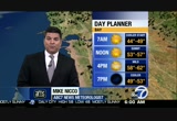
low 60s for redwood city. 63 for san jose and morgan hill. 63 in santa rosa. if you are headed to tahoe, you are in good shape. winds will be light. cold, cold mornings, talking 18 degrees tomorrow morning. by the afternoon. low to mid-upper 40s with sunshine in the forecast for the second half of the day as well. your extended forecast here. there is the warming trend. it as modest one and we will take it. morning fog on saturday. they are predicting the possibility of a little bit of wind coming our way and maybe not so much fog to speak of for sunday. all in all a great looking forecast and the model is showing us we will be dry to about tuesday. >> thank you, are. >>> an earthquake struck japan. several cameras around tokyo captured the shaking and september people running into the streets and there were no major injuries fortunately and the tsunami warning has been lifted. it measured a magnitude of 6.2. >>> well, going green in down town san jose. the pilot program getting underway and cutting cars in the city. those are remembered today who helped launc
low 60s for redwood city. 63 for san jose and morgan hill. 63 in santa rosa. if you are headed to tahoe, you are in good shape. winds will be light. cold, cold mornings, talking 18 degrees tomorrow morning. by the afternoon. low to mid-upper 40s with sunshine in the forecast for the second half of the day as well. your extended forecast here. there is the warming trend. it as modest one and we will take it. morning fog on saturday. they are predicting the possibility of a little bit of wind...
137
137
Dec 5, 2012
12/12
by
KBCW
tv
eye 137
favorite 0
quote 0
pet lum asanta rose -- petaluma, santa rosa. through the night and for tomorrow, rain moving in, and the heaviest of the rainfall which won't be that heavy but it'll have a high impact because it's going to be calling between 7:00 and 9:00 tomorrow morning. find out what happens after this rain-maker moves out. >>> and you can track the rain anytime with our doppler radar on our website. >>> the housing market is making a big exact. u.s. home prices raised more than 6% in october compared to a year ago. that is the greatest yearly gain since july 2006. prices increased in 45 states in october including california. >> we're considerably higher in the bay area than the rest of the country. our entry level homes are tough. so when you start sees homes in the east bay for $250,000, people are lining up for them. >> what's making home buying more affordable? mortgage rates are near record low, while rents are on the rise. >>> we are due to fall off the fiscal cliff in four weeks. tonight each side still insists the other's plan is im
pet lum asanta rose -- petaluma, santa rosa. through the night and for tomorrow, rain moving in, and the heaviest of the rainfall which won't be that heavy but it'll have a high impact because it's going to be calling between 7:00 and 9:00 tomorrow morning. find out what happens after this rain-maker moves out. >>> and you can track the rain anytime with our doppler radar on our website. >>> the housing market is making a big exact. u.s. home prices raised more than 6% in...
153
153
Dec 5, 2012
12/12
by
KRON
tv
eye 153
favorite 0
quote 0
in santa rosa and pelham of the showers have tapered off. take a look at the yellow and orange on your screen over san francisco crossing the bay bridge. it is currently raining along market street downtown san francisco, sunset boulevard, and 19th avenue leaving the city and approaching interstate 280. it is running around s f o we are seeing delays on arriving flights. heavy rain over interstate 280 and the bayshore freeway as well. a quick sample of the rain fall rate. 3 tenths of an inch per hour around millbrae. the same story in san mateo. we are seeing some heavy rain in the bay area. you can see the yellow on your screen over rendell approaching lafayette. remember this is pushing its way east to moving south. we want to take a look when the heavy rain will hit. you can expect the yellow to hit walnut creek around 7:16 a.m. this morning. it will be a relatively slow-moving system of the heavy rain over the east shore freeway. the, most of oakland. as we turn our attention to the south bay light rain it is more widespread with the hea
in santa rosa and pelham of the showers have tapered off. take a look at the yellow and orange on your screen over san francisco crossing the bay bridge. it is currently raining along market street downtown san francisco, sunset boulevard, and 19th avenue leaving the city and approaching interstate 280. it is running around s f o we are seeing delays on arriving flights. heavy rain over interstate 280 and the bayshore freeway as well. a quick sample of the rain fall rate. 3 tenths of an inch...
178
178
Dec 9, 2012
12/12
by
KPIX
tv
eye 178
favorite 0
quote 0
meanwhile tonight get out that extra blanket. 37 degrees overnight in santa rosa into penn grove. also 37 degrees in livermore. pleasanton. dublin and san ramone. low 40s common around san jose back into the valley and then we lift up to the upper 30s and low 40s around the peninsula. 48 in san francisco. this is the area of low pressure not too big albeit spreading a little bit of light rain showers around sat successful that translating no snow. but notice these clouds are drifting across the northwestern section of the state of california. dirty ridge of high pressure allowed us to cloud up today but this ridge of high pressure pushes in from the eastern pacific. sunshine and an offshore flow for your sunday. watch futurecast. clouds kicks on by and we clear out. we will wake up to some stratus overnight and tomorrow morning around the north bay areas, the valleys and also the delta. otherwise that will clear and notice the sunshine all the bay through your sunday. we're going to use pinpoint your neighborhood forecast into the 60s at the beaches. in fact, as you take a look at
meanwhile tonight get out that extra blanket. 37 degrees overnight in santa rosa into penn grove. also 37 degrees in livermore. pleasanton. dublin and san ramone. low 40s common around san jose back into the valley and then we lift up to the upper 30s and low 40s around the peninsula. 48 in san francisco. this is the area of low pressure not too big albeit spreading a little bit of light rain showers around sat successful that translating no snow. but notice these clouds are drifting across the...
338
338
tv
eye 338
favorite 0
quote 0
santa rosa did manage 63 degrees. compared to san rafael, 55. 59 in san francisco. 65 in oakland. 57 only in antioch. 60 in livermore, and san jose, 62. currently napa, the 40s. 47 right now. san francisco, 54. 57 in oakland. and 53 in livermore. 55 right now with some high clouds passing overhead in san jose. we'll go with patchy dense fog in some of the protected valley areas overnight. get ready for warmer days the next few days and then start to cool things down, bringing in showers as we get into wednesday and thursday. overnight lows tonight, thanks to the thin veil of clouds, will be a few degrees warmer. so it's going to be dmold the north bay but maybe agent above the freezing mark. so 36 for napa. livermore valley yeah, upper 30s as well. 40s elsewhere, with one of the warmest lock indication, san francisco. forecasting 47-degrees there. high pressure, a dirty ridge, we know it is because it's allow something of these clouds to sink in across the bay area. but it is definitely kicking the storm track well to
santa rosa did manage 63 degrees. compared to san rafael, 55. 59 in san francisco. 65 in oakland. 57 only in antioch. 60 in livermore, and san jose, 62. currently napa, the 40s. 47 right now. san francisco, 54. 57 in oakland. and 53 in livermore. 55 right now with some high clouds passing overhead in san jose. we'll go with patchy dense fog in some of the protected valley areas overnight. get ready for warmer days the next few days and then start to cool things down, bringing in showers as we...
218
218
Dec 5, 2012
12/12
by
KRON
tv
eye 218
favorite 0
quote 0
santa rosa and petaluma most of the north bay is getting a break. the yellow on your screen we're picking up garbage in red indicates downpours. san francisco under the gun. market street the downtown area pacific heights even richmond and the sunset contending with prearrange. we are getting a little bit of a break. san mateo under the green which indicates relatively light rain. the rain is picking up in pacifica and what that is going to do is get us to continue to push its way east. we take a look at when the heavy rain will hit it looks like 7:41 a.m. for millbrae and 7:45 a.m. for borland game. heavy rain over highway 92 and the san mateo bridge-- buklinggame --burlinggame. even seemingly yellow for oakland and piedmont. as we take it to the south bay they were the last to be hit with heavy rain. sunnyvale, santa clara, cupertino of contending with the yellow which indicates rain falling ride around 3 tenths of an inch per hour. this is a slow-moving system we did mention the winds were not a factor. they will pick up into the afternoon we're
santa rosa and petaluma most of the north bay is getting a break. the yellow on your screen we're picking up garbage in red indicates downpours. san francisco under the gun. market street the downtown area pacific heights even richmond and the sunset contending with prearrange. we are getting a little bit of a break. san mateo under the green which indicates relatively light rain. the rain is picking up in pacifica and what that is going to do is get us to continue to push its way east. we take...
247
247
Dec 7, 2012
12/12
by
KPIX
tv
eye 247
favorite 0
quote 0
only 55 degrees in santa rosa. 57 in concord and 59 in san jose. plenty of sunshine after patchy fog early on. still through the afternoon, mostly sunny skies and should be pleasant this afternoon. need to watch out for chilly temperatures and patchy dense fog, and a much warmer weekend, especially sunday with the offshore winds. sunny and dry. the jet stream lingering to the north will continue to lift so the rain line staying well to the north. that will keep us nice and dry throughout the weekend. another concern if you're traveling in the central valley watch out for the tule fog. high country looking good, mainly in the 50s there. other than a couple of passing clouds this afternoon, looking like some great weather ahead and late tonight, likely seeing patchy ground fog beginning to develop in the interior valleys. enjoying a dry day, 63 in san jose. 60 in san mateo. and 50s and 60s this afternoon and as you head inside the bay, lots of sunshine, 50s and 60s for highs. next couple of days including the weekend, what a difference from last week
only 55 degrees in santa rosa. 57 in concord and 59 in san jose. plenty of sunshine after patchy fog early on. still through the afternoon, mostly sunny skies and should be pleasant this afternoon. need to watch out for chilly temperatures and patchy dense fog, and a much warmer weekend, especially sunday with the offshore winds. sunny and dry. the jet stream lingering to the north will continue to lift so the rain line staying well to the north. that will keep us nice and dry throughout the...
203
203
Dec 10, 2012
12/12
by
KRON
tv
eye 203
favorite 0
quote 0
seventies the possibility north of santa rosa. it is turning out to be a nice day around the bay area. your afternoon highs temperatures above average. 66 for oakland. 63 exit for cochrane fairfield. we do have changes high pressure in control for now. what will happen in area of low pressure will drop down from the gulf of alaska bringing cool air into the bay area. it will be a cold one by the middle of this week. we do expect rain 11:00 p.m. tuesday night. f mostly cloudy conditions not until the overnight hours where we start to see some showers. it will approach from the north bay first. we could see between a quarter and and half inch of rain here in the bay area. this is not a heavy system, in fact it will bring scattered showers. it will be dry thursday into friday. we have another storm system headed our way saturday and sunday. this one to bring more moderate rain to the bay area keep an umbrella handy. full details on what to expect coming up in a bit. >> over to the traffic center it is quiet on the freeway. the approa
seventies the possibility north of santa rosa. it is turning out to be a nice day around the bay area. your afternoon highs temperatures above average. 66 for oakland. 63 exit for cochrane fairfield. we do have changes high pressure in control for now. what will happen in area of low pressure will drop down from the gulf of alaska bringing cool air into the bay area. it will be a cold one by the middle of this week. we do expect rain 11:00 p.m. tuesday night. f mostly cloudy conditions not...
450
450
Dec 8, 2012
12/12
by
KTVU
tv
eye 450
favorite 0
quote 0
santa rosa 56, oakland, 56 with winds not too much of a factor. if you're looking toward the bay waters earlier today, i noticed the calm conditions. satellite, no rain drops expected. in fact the storm track heading to the north of the bay area so we can guarantee you a dry weather pattern and a temperature change. if you are headed o to lake tahoe you can see some winds and afternoon highs around lake level maxing in the 40s. . >> hee here is a look at the chilly overnight los, first thing in the morning, temperatures have been cooling off o over the past few mornings and will continue with that. nap pa forecast, 34 and we could have some patchy dense fog to start the day. so here we go, saturday morning, 7:00, showing you the 30s, and widespread 40s across the region. as we put this into motion, the temperature scale goes up with the readings back in the upper 50s but most areas making it to the 60s. we'll show you the forecast temperature in your neighborhood for saturday, the temperature change you can expect for sunday and when shower chance
santa rosa 56, oakland, 56 with winds not too much of a factor. if you're looking toward the bay waters earlier today, i noticed the calm conditions. satellite, no rain drops expected. in fact the storm track heading to the north of the bay area so we can guarantee you a dry weather pattern and a temperature change. if you are headed o to lake tahoe you can see some winds and afternoon highs around lake level maxing in the 40s. . >> hee here is a look at the chilly overnight los, first...
277
277
Dec 5, 2012
12/12
by
KRON
tv
eye 277
favorite 0
quote 0
moderate to heavy rain expected stretching north of santa rosa. north of san rafeal it will push into naftnapa and hug the coast line. it will shshift by afternoon. the showers will taper off dry conditions at the golden gate bridge. showers of the south bay by 7:00 p.m. tonight. dry conditions were pretty much everyone slated for the overnight hours. here's a look at temperatures. mild starts to the morning. 57 for novato. 64 oakland. 64 san mateo. your afternoon highs will see low 60s a lot of cloud cover and again the chance for a off and on shower. 624 san francisco. 64 in hayward and oakland. your kron 4 7 day around the bay forecast shows a dry pattern starts to develop around the bay area it will continue to be pleasant with mild conditions in to the weekend in starting the next work week. that is your forecast i will have more on that storm coming up in a bit. we do have some roadways flooding northbound 101 in petaluma approaching the old redwood highway. be aware. caltran is currently on the scene. here is the approach to the bay bridge
moderate to heavy rain expected stretching north of santa rosa. north of san rafeal it will push into naftnapa and hug the coast line. it will shshift by afternoon. the showers will taper off dry conditions at the golden gate bridge. showers of the south bay by 7:00 p.m. tonight. dry conditions were pretty much everyone slated for the overnight hours. here's a look at temperatures. mild starts to the morning. 57 for novato. 64 oakland. 64 san mateo. your afternoon highs will see low 60s a lot...
260
260
tv
eye 260
favorite 0
quote 1
let's take about what waits for you. 37 santa rosa, 40 napa, a lot of 40s around our neighborhoods until you get to mountain view and san jose, 50 in mountain view and 51 san jose. the bay starting off with sunshine, mid to upper 40s. by noon mid to upper 50s. you can see mild this afternoon, close to average upper 50s to low 60s, heavier coat by 7:00, temperatures in the upper 40s to mid 50s for your evening nest fifths. -- evening festivities. upper 50s at the coast, fog stubborn inland visibilities down quarter mile or less in some areas that is going to hold temperatures back, afternoon sun upper 50s to low 60s. >>> so far friday light smooth sailing northbound 87 san jose traffic at the limit no problems past hp pavilion northbound. bunching up a little where 580 merges with 80, slow traffic in the westbound direction, a lot of headlights towards the macarthur maze and berkeley curve into the bay bridge toll, expecting m l any time it is moving, not -- expecting metering lights a time but it is moving. a look at our traffic app n is the waze app, mike has been talking about fog, our
let's take about what waits for you. 37 santa rosa, 40 napa, a lot of 40s around our neighborhoods until you get to mountain view and san jose, 50 in mountain view and 51 san jose. the bay starting off with sunshine, mid to upper 40s. by noon mid to upper 50s. you can see mild this afternoon, close to average upper 50s to low 60s, heavier coat by 7:00, temperatures in the upper 40s to mid 50s for your evening nest fifths. -- evening festivities. upper 50s at the coast, fog stubborn inland...
157
157
Dec 5, 2012
12/12
by
KPIX
tv
eye 157
favorite 0
quote 0
still cloudy but no rain yet except for the north bay up towards santa rosa where you're at 55. san jose, livermore 61. oakland 62. concord 58 degrees. have you noticed how cloudy it's been? out of the past 19 days almost the past three weeks we have only had three sunny days. i'm showing you this graphic not to disappoint you but to let you know something is going to be changing and sunshine will come back not tonight or tomorrow. high-def doppler radar tracking showers primarily in the north bay and offshore. rain for everybody tomorrow but several more hours before that rain moves into san jose, fremont, oakland and redwood city. your lows tonight in the low 50s. concord 51. a little milder tonight because we have cloud cover. another cloudy day today. but there's a difference between this weathermaker and the past several. one, it's not as juicy. there's not as much moisture in the atmosphere and two, we have an area of high pressure building in from the south which has shoved the storm track farther up to the north. it's pouring in seattle. it's pouring in portland. it's po
still cloudy but no rain yet except for the north bay up towards santa rosa where you're at 55. san jose, livermore 61. oakland 62. concord 58 degrees. have you noticed how cloudy it's been? out of the past 19 days almost the past three weeks we have only had three sunny days. i'm showing you this graphic not to disappoint you but to let you know something is going to be changing and sunshine will come back not tonight or tomorrow. high-def doppler radar tracking showers primarily in the north...
123
123
Dec 4, 2012
12/12
by
KTVU
tv
eye 123
favorite 0
quote 0
if we get in a little bit closer, you can see a few scattered showers into healdsburg, santa rosa, bodega bay, we're seeing some of this rain. we'll continue to see the scattered showers. guerneville you are looking a few showers. napa, vacaville and fairfield. this will remain over the north bay through most of the afternoon. hit or miss showers, periods of rain, a few periods of dry weather. it will spread south and when it does, the steadier rain will begin to move our way. coming up, i will tell you when we can expect the evening drive, when we'll see the heaviest rain and when we'll be dry. >>> in san mateo county, road crew are the trying to shore up highway 1 before the rain tonight. they are trying to stop erosion from the weekend storm in pacifica. that will mean traffic delays in the area the highway was completely shut down overnight until the work began at 9:00 a.m. there are one-way controls in place right now. they hope to have everything back open by 3:00 this afternoon. >>> in a couple of hours, the san francisco board of supervisors will cast their final vote on the publi
if we get in a little bit closer, you can see a few scattered showers into healdsburg, santa rosa, bodega bay, we're seeing some of this rain. we'll continue to see the scattered showers. guerneville you are looking a few showers. napa, vacaville and fairfield. this will remain over the north bay through most of the afternoon. hit or miss showers, periods of rain, a few periods of dry weather. it will spread south and when it does, the steadier rain will begin to move our way. coming up, i will...
169
169
Dec 8, 2012
12/12
by
KTVU
tv
eye 169
favorite 0
quote 0
santa rosa 40 degrees right now. 41 at napa. in overnight hours around sunrise, we slipped into the low to mid-30s. so an improvement. 46 in oakland. but that said, it's still with a chill out there. 63 in oakland for the afternoon. 62 in fremont. fast forward to wednesday morning, we may wake up with scattered showers. passing by the afternoon, but roll into thursday because you can see you may be a little unsettled there. between now and then, some dry nice weather in store. tomorrow will be the warmer day, monday mostly sunny, mid up toker 60s in the forecast as well. and then we see a transition on tuesday. the wet weather holds off until wednesday. but the model is going to bring us scattered showers and unsettled through thursday. back to you. >>> more than 200 patients across the nation were given a early christmas gift day, the gift of mobility. 1 surgeons provided free joint replacements to those who don't qualify for government assistance and don't have health insurance. a team participated in the program giving one wo
santa rosa 40 degrees right now. 41 at napa. in overnight hours around sunrise, we slipped into the low to mid-30s. so an improvement. 46 in oakland. but that said, it's still with a chill out there. 63 in oakland for the afternoon. 62 in fremont. fast forward to wednesday morning, we may wake up with scattered showers. passing by the afternoon, but roll into thursday because you can see you may be a little unsettled there. between now and then, some dry nice weather in store. tomorrow will be...
327
327
Dec 9, 2012
12/12
by
KTVU
tv
eye 327
favorite 0
quote 1
lots of mid-30s for santa rosa and napa. san josi forecasted low around 43 degrees. had to snap this picture from this afternoon into the evening hours, beautiful with a few high clouds. you can see the high clouds showing up on the satellite the high pressure continues to build offshore. first thing sunday morning could be some gusty winds especially up in the hills around 30 miles per hour. but some of the stronger winds close to the surface, around the delta, 25 miles per hour. so a bit of a breeze for your sunday. temperatures though will be warming back up around 60-68 degrees. our forecast model showing you most of the organized fog out to our east. as a mentioned a few patches developing in the inland valleys. more sunshine into the evening hours, but breezy out towards to the higher terrain. san josi around 66 and san mateo, 64. here is a look ahead your five- day forecast and into monday, still a fairly nice weather pattern. if you missed the rain already, we're talking about more rain showers by wednesday. a chance of showers into thursday morning. also a m
lots of mid-30s for santa rosa and napa. san josi forecasted low around 43 degrees. had to snap this picture from this afternoon into the evening hours, beautiful with a few high clouds. you can see the high clouds showing up on the satellite the high pressure continues to build offshore. first thing sunday morning could be some gusty winds especially up in the hills around 30 miles per hour. but some of the stronger winds close to the surface, around the delta, 25 miles per hour. so a bit of a...
176
176
Dec 10, 2012
12/12
by
KPIX
tv
eye 176
favorite 0
quote 0
and 42 in santa rosa. we have this big ridge of high pressure and it is sitting firm over the pacific, over the bay area. that's what's keeping us high and dry. today and tomorrow. now, by tomorrow night, that's when things start to get a little dicey. we're watching a low pressure system to the north and that is going to move our way bringing a good chance of rain by midweek. in the meantime, we'll focus on mild temperatures for today. a lot of 60s, mid- to upper 60s across the bay area. hopefully you enjoyed yesterday. it's going to be a similar story today. we're hitting a repeat on yesterday's forecast. coming up, we will get a check o. 7-day forecast because -- of that 7-day forecast because you will want to stay tuned for that. >>> 5:04 now, grammy nominated latina musician from the united states is dead after her plane crashed in mexico. a small plane carrying jenny rivera went down shortly after takeoff in mexico. 7 people were on board. rivera's california driver's license was found at the crash s
and 42 in santa rosa. we have this big ridge of high pressure and it is sitting firm over the pacific, over the bay area. that's what's keeping us high and dry. today and tomorrow. now, by tomorrow night, that's when things start to get a little dicey. we're watching a low pressure system to the north and that is going to move our way bringing a good chance of rain by midweek. in the meantime, we'll focus on mild temperatures for today. a lot of 60s, mid- to upper 60s across the bay area....
265
265
Dec 9, 2012
12/12
by
KPIX
tv
eye 265
favorite 0
quote 0
in santa rosa, 37 degrees. concord, 44. livermore's got 42. already in the city, 52 degrees, lots of blue up there. we still have some high clouds floating overhead here and there. here's what we'll be expecting next. few high clouds today. don't forget the winds out of the northwest, kind of a dry direction. chapped skin kind of weather. lots of sunshine. next rain coming in on wednesday. and the time lapse here, you can see what's unfolded over the last 24 hours. low pressure is just climbing over the top, over british columbia. for us, sunny and breezy today will do it. over the rest of northern california, if you're heading out, dense fog advisories posted until 9:00 this morning from the southern end of the sacramento valley, right down through the san joaquin valley. 65 degrees in monterey, 67 and sunny. out of the bay area, mostly sunny skies at the airport, winds out of the northwest to about 30. new york's got rain. but for the rest, just clouds in denver and chicago. chicago, just 34. los angeles at 73. back in the bay area, the numb
in santa rosa, 37 degrees. concord, 44. livermore's got 42. already in the city, 52 degrees, lots of blue up there. we still have some high clouds floating overhead here and there. here's what we'll be expecting next. few high clouds today. don't forget the winds out of the northwest, kind of a dry direction. chapped skin kind of weather. lots of sunshine. next rain coming in on wednesday. and the time lapse here, you can see what's unfolded over the last 24 hours. low pressure is just climbing...
319
319
Dec 10, 2012
12/12
by
KPIX
tv
eye 319
favorite 0
quote 0
but then look at santa rosa where we're getting reports o of fog and 39 degrees there. pretty wide temperature spread as you wake up this morning, just kind of depending on where you are. by this afternoon, everyone should see center line. see-- sunshine. and pretty mild conditions. check out the numbers. in some of our inland shot spot thes. looks likes through tomorrow we're going to remain dry and time things out with future cast. we have big changes coming by midweek. tuesday night, we'll freeze here at 10:00 p.m. we're watching this low system. it's a storm to the north and will bring rain showers tuesday night, and wednesday afternoon and wednesday evening should clear out of here. we're not expecting whole lot of rain with that system, possibly a half inch, likely less. it's going to quickly move out of here, but things remain unsettled through the weekend. we're going to enjoy the mild temperatures temperatures well above average. close to record breakers in some spots. 66 in oakland. mid-60s in san francisco. 63 if you're out in concord. here's a look at your f
but then look at santa rosa where we're getting reports o of fog and 39 degrees there. pretty wide temperature spread as you wake up this morning, just kind of depending on where you are. by this afternoon, everyone should see center line. see-- sunshine. and pretty mild conditions. check out the numbers. in some of our inland shot spot thes. looks likes through tomorrow we're going to remain dry and time things out with future cast. we have big changes coming by midweek. tuesday night, we'll...
288
288
Dec 5, 2012
12/12
by
KPIX
tv
eye 288
favorite 0
quote 0
widespread showers from santa rosa all the way down to santa cruz. we are looking at some heavy showers. and then rain moving out by tomorrow evening. then clouds move out thursday 1:00 in the afternoon mainly sunny. highs tomorrow with the rain around low 60s oakland 63, san jose 63, palo alto 62. you will have showers at times for pleasant hill, pittsburg, antioch, highs in the low 60s and a steady rainfall overnight and tomorrow morning for santa rosa. your high 61. san francisco 61 degrees tomorrow. once we're finished with tomorrow's rain, it is smooth sailing highs around 60. overnight lows chilly but we'll be sunny for six straight days after wednesday. that's your cbs 5 forecast. sports is coming up next. [ laughter ] [ girl ] wow, you guys have it easy. i wish i had u-verse when i was your age. in my day, we didn't have these fancy wireless receivers. blah blah blah. if i had a sleepover, i couldn't just move the tv into the playroom. no. we had to watch movies in the den because that's where the tv outlet was. and if dad was snoring on the
widespread showers from santa rosa all the way down to santa cruz. we are looking at some heavy showers. and then rain moving out by tomorrow evening. then clouds move out thursday 1:00 in the afternoon mainly sunny. highs tomorrow with the rain around low 60s oakland 63, san jose 63, palo alto 62. you will have showers at times for pleasant hill, pittsburg, antioch, highs in the low 60s and a steady rainfall overnight and tomorrow morning for santa rosa. your high 61. san francisco 61 degrees...
294
294
Dec 6, 2012
12/12
by
KPIX
tv
eye 294
favorite 0
quote 0
santa rosa approaching an inch and over an inch in san francisco. there you have that stat in oakland, as well. overnight tonight with the blanked of clouds numbers in the 40s and 50s. we'll see pockets of fog, as well. then we'll start to see the clouds gradually breaking up in the overnight hours leaving us with some areas of fog for tomorrow morning's commute. otherwise, we will have partly sunny conditions. wait until that you see seven- day forecast. first things first. pinpointing your neighborhood, 50s beaches. tomorrow for your thursday, 60s around the peninsula. jumping up to the low 60s as we swing around to the santa clara valley including willow glen, alum rock and alviso. east of the bay especially well inland topping off at 63, 46 degrees for the warmest locations. otherwise, 60 in walnut creek. this is similar to what we experienced today as far as our numbers are concerned, 60s in san francisco and kentfield. the extended forecast, nothing but sunshine and seasonal temperatures each and every day allowing us all to dry out just a bit
santa rosa approaching an inch and over an inch in san francisco. there you have that stat in oakland, as well. overnight tonight with the blanked of clouds numbers in the 40s and 50s. we'll see pockets of fog, as well. then we'll start to see the clouds gradually breaking up in the overnight hours leaving us with some areas of fog for tomorrow morning's commute. otherwise, we will have partly sunny conditions. wait until that you see seven- day forecast. first things first. pinpointing your...
246
246
Dec 2, 2012
12/12
by
KRON
tv
eye 246
favorite 0
quote 0
santa rosa, a little bit of the dry break as a presses south-eastern gusting. the yellow, the red is indicating a heavy downpour. santa rosa getting a break but towards novado and the east bayshore fajita heavy rain but not quite that downpour it is pressed inland. antioch 1 in. per hour. as for the coastal in peninsula area is not quite as intense it is continuing to press south. the yellow and red indicating a couple of inches per hour. you can see the watches and warnings impacting the russian river, napa both expected to exceed the flood stages. fifth that is in combination with this already saturated soil from the past two storms. including this third storm with down trees, power lines already a lot of power outages and the high wind advisory for most of the bay area life full-color olive your screen. sustained when speeds at 20-30 m.p.h. gusting to 50 m.p.h. we will track far it will be felt, as the effect is itself fifth fair the strong winds are to blame. take a look. toppled a truck on the richmond san rafael bridge and slowed air traffic at sfo new th
santa rosa, a little bit of the dry break as a presses south-eastern gusting. the yellow, the red is indicating a heavy downpour. santa rosa getting a break but towards novado and the east bayshore fajita heavy rain but not quite that downpour it is pressed inland. antioch 1 in. per hour. as for the coastal in peninsula area is not quite as intense it is continuing to press south. the yellow and red indicating a couple of inches per hour. you can see the watches and warnings impacting the...
248
248
Dec 10, 2012
12/12
by
KRON
tv
eye 248
favorite 0
quote 0
as we step out the door 39 santa rosa. 50 degrees in haywood. i will show you were the numbers are expected to go in to the afternoon coming up in my next report robyn. >> thank you erica here at the bay bridge a hot spot. because of three earlier stalls. it has backed up your ride into san francisco. the drive time has doubled within the last hour. the traffic is backed up to the 80 over crossing. the back of stretches into the oakland maze. we have a stall near treasure island was at the incline and one on the span all out of the way. the damage is done. light on an traffic backed up. give yourself extra time heading into san francisco. if you're looking for an alternate you can go to 92 and across the san mateo bridge to get into san francisco. off your back up expense on the east shore freeway. westbound right on 80 is slow starting in the mall. it will be stop and go through some of low, richmond, an albany. all leading to traffic heading to san francisco. >> the full check of traffic coming up in just a bit more. >> following a up the stor
as we step out the door 39 santa rosa. 50 degrees in haywood. i will show you were the numbers are expected to go in to the afternoon coming up in my next report robyn. >> thank you erica here at the bay bridge a hot spot. because of three earlier stalls. it has backed up your ride into san francisco. the drive time has doubled within the last hour. the traffic is backed up to the 80 over crossing. the back of stretches into the oakland maze. we have a stall near treasure island was at...
269
269
Dec 3, 2012
12/12
by
KRON
tv
eye 269
favorite 0
quote 0
tomorrow maybe and sprinkle up around santa rosa. light rain anticipated for napa, vallejo around the rich and san rafeal bridge. as we put the clock into motion it will not be until later that night we will start to see rain south of the golden gate. it will pick up in intensity over the night while people are sleeping. 9:00 a.m. wednesday we could see heavy rain for the bay. your kron 4 7 day around the bay forecast in showing rain for tuesday and wednesday dryer by next thursday. friday will be mainly sunny and dry conditions will persist. the mild weekend on tap for saturday and sunday. 8:18 a.m. at your weather here is traffic morning george. >> good morning air gust of a stock on the dimmest tying up traffic in the southbound direction also slowing the northbound right. slow traffic in the northbound direction that is to be expected for the nimitz at this hour. checking the bridges as we look at your bbay bridge ride westbound a reporter saw in our last updated has been removed and it did not have a big impact. the 880 approach
tomorrow maybe and sprinkle up around santa rosa. light rain anticipated for napa, vallejo around the rich and san rafeal bridge. as we put the clock into motion it will not be until later that night we will start to see rain south of the golden gate. it will pick up in intensity over the night while people are sleeping. 9:00 a.m. wednesday we could see heavy rain for the bay. your kron 4 7 day around the bay forecast in showing rain for tuesday and wednesday dryer by next thursday. friday will...
237
237
Dec 6, 2012
12/12
by
KRON
tv
eye 237
favorite 0
quote 0
santa rosa is a 52 degrees. future cast for temperatures by noon it will be in the '60s. >> most of us will be in the low to mid 60's so it will be a fairly nice day especially with the sun. we will cool down this afternoon, right around the '50s for most areas by 8:00 p.m.. it will be a pretty pleasant evening. you should get ready for more sunshine for friday and into the weekend. it temperatures in the south bay are low 60's for santa clara and san jose. fremont will get up to 61 degrees. the east bay will be in the lower 60s as well. fairfield will come in at 62 degrees. the north bay will be in the upper 50s close to 60's. this is force san rafael and downtown san francisco. richman will get up to 59 degrees. we will stay dry for the next several days and a warming trend will be for the weekend. >> friday will be even more sunshine but friday and saturday morning we may have fog. you should keep your eye on this. once the fog burns off a lot sunshine is expected. sunday will be near 60's. this will be a gre
santa rosa is a 52 degrees. future cast for temperatures by noon it will be in the '60s. >> most of us will be in the low to mid 60's so it will be a fairly nice day especially with the sun. we will cool down this afternoon, right around the '50s for most areas by 8:00 p.m.. it will be a pretty pleasant evening. you should get ready for more sunshine for friday and into the weekend. it temperatures in the south bay are low 60's for santa clara and san jose. fremont will get up to 61...
190
190
Dec 4, 2012
12/12
by
KRON
tv
eye 190
favorite 0
quote 0
as we go towards santa rosa, mount st. helena. and decent conditions that help to try things out a little bit today. it will be a little bit for the air to get saturated enough for the rain to hit the ground. most of that moisture is missing us. but the storm is still offshore and packing plenty of moisture. going towards tomorrow and here is what we expected. the increasing clouds and the north bay shower but i do not think it will record to see any rainfall until 5:00. mainly, north bay shores but wednesday, more whitetiming it out on futurecast. more widespread totals. >> the wonder of cdc's that this coming flu season and 3 warnings from the cdc. there is prevention but you have to take action now dan kerman. >> if you've not gotten a flu shots you should consider one. the flu season is are arriving earlier than usual. >> it is unusual to a peaks in december and january is usually the main one. this year it looks like on the eastern portion is already building up steam heat. >> kaiser and walnut creek say that this is strain i
as we go towards santa rosa, mount st. helena. and decent conditions that help to try things out a little bit today. it will be a little bit for the air to get saturated enough for the rain to hit the ground. most of that moisture is missing us. but the storm is still offshore and packing plenty of moisture. going towards tomorrow and here is what we expected. the increasing clouds and the north bay shower but i do not think it will record to see any rainfall until 5:00. mainly, north bay...
137
137
Dec 5, 2012
12/12
by
KTVU
tv
eye 137
favorite 0
quote 0
some of the rain totals santa rosa almost an inch of rain. inch and a third -- napa half inch of rain. kentfield two bits. i think that will pick up pretty rapidly here as that system enhances off san francisco marin and san mateo coast. cloudy north, cloudy south. that rain moving south and east some of it is drizzle. very mild. 60s on the temps. this is our last system in this pattern and then things will change. fog will be a huge issue thursday and friday. weekend looks dry. >>> time now 6:39. happening right now nancy pelosi holding a news conference with other congressional leaders. let's listen in. >> and our ranking members imparticular are portrait of diversity, bold leadership, and a firm commitment to america's middle class. the first caucus where the majority are women minorities, etc.. >> that is nancy pelosi, maxine waters, henry waxman to the left standing behind her. all from california. she filed a petition to vote on a bill in the house to raise tax rates on upper income americans. it's a bill already passed in the senate bu
some of the rain totals santa rosa almost an inch of rain. inch and a third -- napa half inch of rain. kentfield two bits. i think that will pick up pretty rapidly here as that system enhances off san francisco marin and san mateo coast. cloudy north, cloudy south. that rain moving south and east some of it is drizzle. very mild. 60s on the temps. this is our last system in this pattern and then things will change. fog will be a huge issue thursday and friday. weekend looks dry. >>>...
172
172
Dec 4, 2012
12/12
by
KPIX
tv
eye 172
favorite 0
quote 0
about 62 in san francisco. 61 in santa rosa. and 61 in daly city. next couple of days, we are going to see some unsettled weather return, showers tomorrow morning. then dry weather returns thursday right into the weekend. >> all right. lawrence, thank you very much. we are starting to see a backup at the bay bridge toll plaza of metering lights are still off but slow conditions as you work your way towards the pay gates there. let's start over on pleasanton -- my fault. westbound 580 as you work your way toward the dublin interchange we are seeing lots of volume actually a few cars headed there. seeing brake lights as well as through the altamont pass. now let's jump to the bay bridge toll plaza. there you go. now we are seeing a backup there. fastrak lanes okay through the area. san mateo bridge not bad at all. traffic looking good in both directions as you work your way between hayward and foster city. 880 and 101 also checking in problem-free. and a look at our golden gate bridge this morning. so far it's been an easy ride. if you are traveling s
about 62 in san francisco. 61 in santa rosa. and 61 in daly city. next couple of days, we are going to see some unsettled weather return, showers tomorrow morning. then dry weather returns thursday right into the weekend. >> all right. lawrence, thank you very much. we are starting to see a backup at the bay bridge toll plaza of metering lights are still off but slow conditions as you work your way towards the pay gates there. let's start over on pleasanton -- my fault. westbound 580 as...
318
318
tv
eye 318
favorite 0
quote 0
even at 38 santa rosa is a couple degrees warmer. san francisco 47. good morning redwood city, 48. 49 in mountain view and a mild, relatively speaking, 50 in san jose. that's five degrees above where you were yesterday but it's really fremont and livermore that are experiencing the much warmer conditions. not much change-up in san rafael, and subtle changes along the coast in san francisco. boy, a pretty mild to start out. just in the last hour numbers coming up along the shoreline. we will look for a little bit of fog here and there, but overall with the cloudy skies this morning that's keeping us a little warmer. then by the afternoon the winds will take over and that's going to usher in a slightly milder air mass. high pressure over the bay area continues to bring that sub continuance and that warming today and tomorrow. but by tuesday it will be coming to a screeching halt as we look for another wind shift. the temperatures will drop and then we will look for showers to head our way late tuesday into wednesday. so some of the forecasted highs toda
even at 38 santa rosa is a couple degrees warmer. san francisco 47. good morning redwood city, 48. 49 in mountain view and a mild, relatively speaking, 50 in san jose. that's five degrees above where you were yesterday but it's really fremont and livermore that are experiencing the much warmer conditions. not much change-up in san rafael, and subtle changes along the coast in san francisco. boy, a pretty mild to start out. just in the last hour numbers coming up along the shoreline. we will...
272
272
Dec 10, 2012
12/12
by
KTVU
tv
eye 272
favorite 0
quote 0
santa rosa, 38. 60 in downtown oakland. that's not a typo. 60 degrees northeast wind about 21 miles an hour coming right off the oakland berkeley hills. high pressure is our fair- weather friend. low pressure is off the coast. high pressure doesn't like low pressure. high pressure fills it with the wind. there's our system coming out of the gulf of alaska. remember, systems come out of the fronts, they don't hold as much moisture but you don't get as much rain. but you will notice the cold coming in. dry pattern until late tuesday, early wednesday. wheelage -- we'll go from 60s to 70s. today will be warmer for most. but some of that patchy fog and a cold morning gives way to breezy and windy conditions. a lot of 60s here. low, mid, to upper. you get enough of the easterly breeze. and that makes it nice. that kind of a pattern. very mild to warm san jose. santa clara valley over to santa cruz. looks nice there as well. about the same on the san mateo coast, in the city and also on the peninsula. sunshine tuesday and then clo
santa rosa, 38. 60 in downtown oakland. that's not a typo. 60 degrees northeast wind about 21 miles an hour coming right off the oakland berkeley hills. high pressure is our fair- weather friend. low pressure is off the coast. high pressure doesn't like low pressure. high pressure fills it with the wind. there's our system coming out of the gulf of alaska. remember, systems come out of the fronts, they don't hold as much moisture but you don't get as much rain. but you will notice the cold...
182
182
tv
eye 182
favorite 0
quote 0
otherwise we are talking mid-60s in oakland, san jose 65, 64 livermore and 65 in santa rosa. down by the monterey bay there is plenty of cloud cover right now but by the afternoon talking warmup with 66 in salinas and 64 gilroy. tomorrow to start the work week, very little change. here comes the cool down with more clouds and perhaps more rain by the overnight hours and more scattered showers on wednesday into thursday. look at the numbers drop a good ten degrees. maybe we will look for a dry day friday but looks like the weekend could be wet again. we will have to see as it gets closer. >> keep an eye on that. thank you, lisa. the 49ers play the miami dolphins this afternoon at candlestick park. the niners are teaming up with operation dream, a local nonprofit to collect toys for needy children. you can bring a new unwrapped toy but no toy guns or weapons for obvious security reasons. cash will also be accepted. volunteers will have collection buckets this the parking lot near stadium entrances. >>> next weekend dela salle high school will go for the state title for the four
otherwise we are talking mid-60s in oakland, san jose 65, 64 livermore and 65 in santa rosa. down by the monterey bay there is plenty of cloud cover right now but by the afternoon talking warmup with 66 in salinas and 64 gilroy. tomorrow to start the work week, very little change. here comes the cool down with more clouds and perhaps more rain by the overnight hours and more scattered showers on wednesday into thursday. look at the numbers drop a good ten degrees. maybe we will look for a dry...
212
212
Dec 7, 2012
12/12
by
KTVU
tv
eye 212
favorite 0
quote 1
still holding -- degrees in santa rosa. still holding on onto the 30s in your air na. 41 in con-- area. 41 in concord. in the bay area, widespread mid- to upper 40s is where we stand at this hour. low 60s in the forecast for your afternoon. that's above average. typically this time of year we're looking at upper 50s for the afternoon. so 62 in novato with a mix of sunshine and high clouds. 62 in oakland. 61 in san francisco. 62 in hayward. as we slide out a little bit. widespread 60s from redwood city, mountain view, gilroy, santa cruz, it's a mostly sunny start. look at your forecast if you are headed to do some skiing in tahoe this week. mostly sunny skies. the overnight lows, brrr! teens and low 20s afternoon highs in the 20s. your extended forecast here at home, it's a great weekend to be here at home whether you are going to do some holiday shopping, get outdoors, maybe an outdoor brunch. temperatures will remain the low to mid-60s for your saturday. perhaps a few upper 60s in time for sunday. back to you. >>> some san
still holding -- degrees in santa rosa. still holding on onto the 30s in your air na. 41 in con-- area. 41 in concord. in the bay area, widespread mid- to upper 40s is where we stand at this hour. low 60s in the forecast for your afternoon. that's above average. typically this time of year we're looking at upper 50s for the afternoon. so 62 in novato with a mix of sunshine and high clouds. 62 in oakland. 61 in san francisco. 62 in hayward. as we slide out a little bit. widespread 60s from...
166
166
Dec 7, 2012
12/12
by
KRON
tv
eye 166
favorite 0
quote 0
santa rosa and now are down at zero. we're still dealing with this in certain areas and parts of the north area and inland valleys. it should clear up by 10:00 a.m.. >> as you set the clock ahead you will be dealt with clear skies. your temperatures have been chilly for the morning starting at 36 degrees. about 30 is for concord and mid 40's for oakland. as we set the clock to 9:00 a.m. we are expecting widespread 50s and by noon time it will be 60's and very similar to yesterday's. for those you are heading up this evening it will draw back out to the '50s. that is a live valley and the south bay will get to the upper 50s this afternoon. 63 degrees in santa rosa, 63 for san rafael. for those of you head into tahoe we're not expecting more snow to fall. it will be very chilly there. belo will be 20s. as we take a look at the 7 day around the bay. >> it will be warmer into the weekend and starting your next work week the temperatures will drop. if there will be a chance to us showers. >> traffic is well-behaved around the
santa rosa and now are down at zero. we're still dealing with this in certain areas and parts of the north area and inland valleys. it should clear up by 10:00 a.m.. >> as you set the clock ahead you will be dealt with clear skies. your temperatures have been chilly for the morning starting at 36 degrees. about 30 is for concord and mid 40's for oakland. as we set the clock to 9:00 a.m. we are expecting widespread 50s and by noon time it will be 60's and very similar to yesterday's. for...
231
231
Dec 9, 2012
12/12
by
KTVU
tv
eye 231
favorite 0
quote 1
we are soaring above yesterday's highs. 67 for santa rosa. and these numbers four to 8 degrees above the seasonal average. 65 expected in oakland. and low 60s in san francisco and out to candlestick to watch the 49ers play, it is a mild one. mid 60s for hayward and down to 66 in san jose. and 67 in morgan hill. how about santa cruz mostly sunny skies and 66 expected in your afternoon. the extended forecast here, we will hold onto the above normal temps through monday. and then we start to see the changes move our way. partly sunny skies. you will feel the transition by the second half of the afternoon. we wake up wednesday afternoon with scattered showers and look at the afternoon high. they take a plunge. expected 50s for the afternoons. i will show you the forecast model on the rain coming up. >>> tragic story out of pennsylvania after a 7-year-old boy is killed by his father's gun. what his dad was doing when the accident happened. >> the death of the nurse in the center of the radio show hoax. what her sister-in-law is now saying. nelson
we are soaring above yesterday's highs. 67 for santa rosa. and these numbers four to 8 degrees above the seasonal average. 65 expected in oakland. and low 60s in san francisco and out to candlestick to watch the 49ers play, it is a mild one. mid 60s for hayward and down to 66 in san jose. and 67 in morgan hill. how about santa cruz mostly sunny skies and 66 expected in your afternoon. the extended forecast here, we will hold onto the above normal temps through monday. and then we start to see...
386
386
tv
eye 386
favorite 0
quote 2
over the past six hours russian river only quarter of an inch, santa rosa half an inch. petaluma a little more than a quarter. let's talk about temperatures dress for mid 50s to low 60s. mid 50s around the monterey bay. rain this morning, showers this afternoon. foggy spots the next couple of nights brighter and drier starting tomorrow. here's that wave we talked about yesterday, hooking up with the front slowing progress bringing us the higher intensity of rain during the morning commute, you can see noon the steadier rain moves east, scattered light showers will continue during the afternoon hours if you have outdoor plans be prepared overnight maybe a stray shower then tomorrow's morning commute all gone a little fog forming then partly sunny and dry thursday afternoon. rainfall amounts up to half inch south bay, up to an inch around the bay and the east bay if you get caught under this training of these storms up to an inch and a half in the north bay. no worries for tailgating tomorrow the game ought to be in the 50s partly cloudy, temperatures slightly cooler, dry
over the past six hours russian river only quarter of an inch, santa rosa half an inch. petaluma a little more than a quarter. let's talk about temperatures dress for mid 50s to low 60s. mid 50s around the monterey bay. rain this morning, showers this afternoon. foggy spots the next couple of nights brighter and drier starting tomorrow. here's that wave we talked about yesterday, hooking up with the front slowing progress bringing us the higher intensity of rain during the morning commute, you...
185
185
Dec 4, 2012
12/12
by
KTVU
tv
eye 185
favorite 0
quote 0
maybe 1 to 2 inches north of santa rosa. south of that, there will be less. any heavy rain would be late tonight. rain will take us into wednesday morning then it is out of here. the pattern changes thursday, friday saturday and then there will be a cooler pattern. dave? >> thank you. >>> traffic changes if you are driving in san mateo county. >> reporter: and we're live in san francisco where public nudity could be on its way out. what people are saying about it as "mornings on 2" continues. >>> welcome back. 8:28. public nudity faces a final vote today in san francisco city hall. brian flores joining us live from the city with the details of what this possible ban would mean today. good morning, brian. >> good morning, dave. there was a preliminary vote in late november as many people know. this was the scene on november 20th. as several people stripped off their clothes insides city hall. we are expecting the same thing today as supervisors take that final vote. what this ordinance would basically do is this -- it would prohibit nudity on public streets, s
maybe 1 to 2 inches north of santa rosa. south of that, there will be less. any heavy rain would be late tonight. rain will take us into wednesday morning then it is out of here. the pattern changes thursday, friday saturday and then there will be a cooler pattern. dave? >> thank you. >>> traffic changes if you are driving in san mateo county. >> reporter: and we're live in san francisco where public nudity could be on its way out. what people are saying about it as...
350
350
Dec 7, 2012
12/12
by
KRON
tv
eye 350
favorite 0
quote 0
and we have 42 in napa, 40's and santa rosa fiord and 44 degrees and san jose. mid '50s along the coast. low 60s in the south bay, the 60s in mountain view, and these temperatures are a few degrees warmer than what we saw today. the same for the inland valleys. low 60s for the east bayshore. 59 in alameda and fifty's closer to the coast. a mixture of 50s and 60s for the north bay. as for the sierras, dry conditions for this weekend it will be easy to get up there and back. mostly sunny skies. temperatures in the 20's! a bit chilly, overnight. they looked at your extended forecast with a dense fog. and low cloud coverage for most of the bay area. fog expected for the inland valleys for the weekend we will expect to see improving conditions with more sunshine. now come off snowbomb... sierra and tahoe, a 60 in. base boreal and 60 inches with more info on snowbomb.com >> let us check the evening commute to. the bay bridge toll plaza. all of these people are going westbound and all lanes even the fast track are backed up. the possible carpel lines are moving along v
and we have 42 in napa, 40's and santa rosa fiord and 44 degrees and san jose. mid '50s along the coast. low 60s in the south bay, the 60s in mountain view, and these temperatures are a few degrees warmer than what we saw today. the same for the inland valleys. low 60s for the east bayshore. 59 in alameda and fifty's closer to the coast. a mixture of 50s and 60s for the north bay. as for the sierras, dry conditions for this weekend it will be easy to get up there and back. mostly sunny skies....
221
221
tv
eye 221
favorite 0
quote 0
we still have 40s this morning in napa and santa rosa, even livermore. but since then the win has allowed for better mixing and that mild air coming into play with the warmer air mass bringing temperatures a bit above normal today, tomorrow, but cooler weather, and a wind shift with stronger on shore winds on tuesday. that will bring the temperatures back into the 50s and then a pretty wet weather maker, a cold one, arrives on wednesday. it looks like it might mess with your wednesday morning commute, as well. you notice the clouds as they move around this big ridge of high pressure, and as they do it's allowing for the winds in the higher elevations, that sinking, subsiding air and warming as we get down to the surface. so as high pressure stays with us the next couple days, it keeps the storm track well up into canada. we are looking not only at the milder weather here, but, in fact, gusty winds in southern california where there is a fire weather watch for san diego. so experiencing unusually warmer weather with plenty of 60s. less tulie fog and numbe
we still have 40s this morning in napa and santa rosa, even livermore. but since then the win has allowed for better mixing and that mild air coming into play with the warmer air mass bringing temperatures a bit above normal today, tomorrow, but cooler weather, and a wind shift with stronger on shore winds on tuesday. that will bring the temperatures back into the 50s and then a pretty wet weather maker, a cold one, arrives on wednesday. it looks like it might mess with your wednesday morning...
 Live Music Archive
 Librivox Free Audio
 Metropolitan Museum
 Cleveland Museum of Art
 Internet Arcade
 Console Living Room
 Books to Borrow
 Open Library
 TV News
 Understanding 9/11